While it's the reigning theory now, the road to acceptance was long and bumpy for plate tectonics, which describes how large portions of Earth's crust slide, grind, rise and sink ever so slowly across its sludgy mantle.
But even now, more than half a century after it was given the scientific tick of approval, the theory needs some refining.
A new study looking at four plateaus in the western Pacific Ocean suggests that these expansive areas aren't rigid slabs but weak spots being yanked apart by distant forces at the plate's edge.
"The theory's not carved in stone and we're still finding new things," says University of Toronto geophysicist Russell Pysklywec, who co-authored the study.
"We knew that geological deformations like faults happen on the continental plate interiors far from plate boundaries. But we didn't know the same thing was happening to ocean plates," adds first author Erkan Gün, also an earth scientist at the University of Toronto.
For decades, scientists have been rewriting their understanding of the seafloor, so this new study is just a continuum of their efforts to chart the ocean's rugged topography.
In the 1950s, ocean cartographer Marie Tharp's pioneering work to map large parts of the seafloor using sonar data from warships showed that the ocean basins weren't at all flat surfaces as scientists had suspected.
Rather, the seafloor was carved up by gaping trenches and massive mountains – none larger than the Mid-Atlantic Ridge, which Tharp discovered, and is now recognized as the longest mountain range on the planet, slicing the Atlantic Ocean in two.
Such mountain ranges form when two tectonic plates collide and Earth's crust buckles, or one plate dips under the other, thrusting the overtopping plate upward. Underwater, though, submarine mountains usually form as two plates drift apart at a so-called divergent boundary and magma spews out.
But far away from these plate boundaries, at the center of oceanic plates, scientists thought that large sections of Earth's crust remained fairly rigid as they drifted atop the mantle, and did not deform like plate edges.
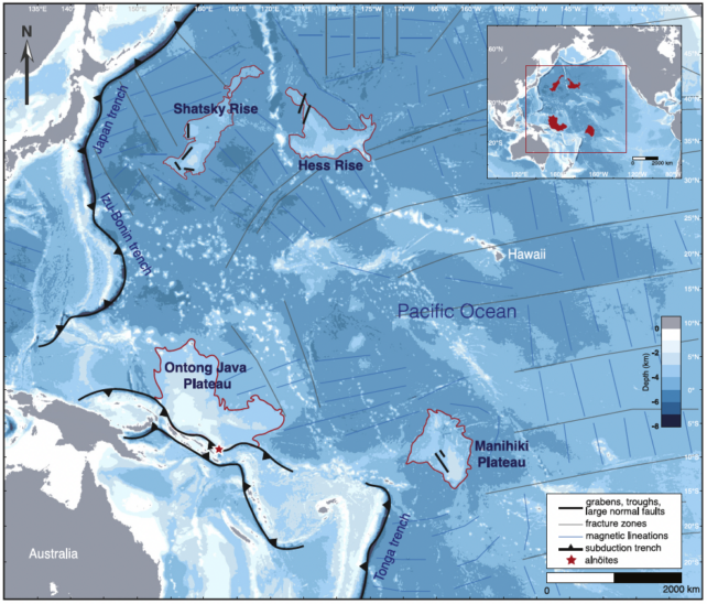
To test this thinking, Gün, Pysklywec, and colleagues gathered existing data on two oceanic plateaus that lie between Japan and Hawaii called the Shatsky Rise and Hess Rise; the Ontong Java Plateau, north of the Solomon Islands; and the Manihiki Plateau, to the northeast of Fiji and Tonga.
Given the challenges in surveying the seafloor, their study was limited to these four plateaus in the western Pacific Ocean for which data were available.

The oceanic plateaus are located hundreds to thousands of kilometers from the nearest plate boundary. Yet Gün and colleagues found the plateaus shared deformational and magmatic features that suggest they are being torn apart by pull forces at the Pacific plate's edge, where slabs are being subducted underneath neighboring plates.
The ruptures, or fault lines, identified by the researchers tend to run parallel to the closest trench, as you can see on the map above.
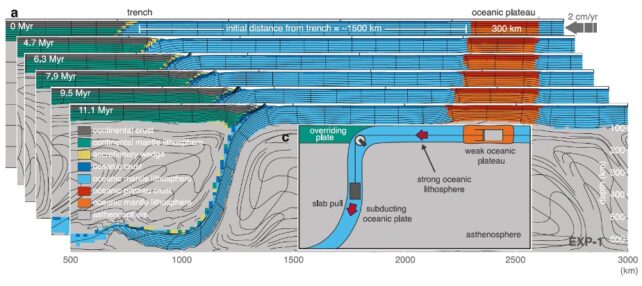
The team also modeled tectonic plate dynamics for four hypothetical plateaus located between 750 and 1,500 kilometers (466 to 932 miles) from the nearest subduction zone, to get a better understanding of the mechanisms giving rise to this distant deformation.

Regardless of their distance from the plate edge, these hypothetical plateaus were stretched over millions of years and thinned more on the side closest to the trench.
"It was thought that because the sub-oceanic plateaus are thicker, they should be stronger," Gün says. "But our models and seismic data show it's actually the opposite: the plateaus are weaker."
Acknowledging they only analyzed four Pacific plateaus, the researchers hope their findings spur further explorations to map the seafloor.
"Sending research vessels to collect data is a major effort," Gün says. "So, in fact, we're hopeful our paper brings some attention to the plateaus and more data will be collected."
The study has been published in Geophysical Research Letters.
